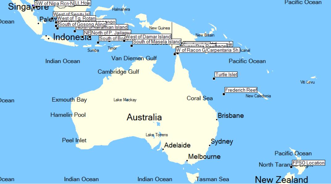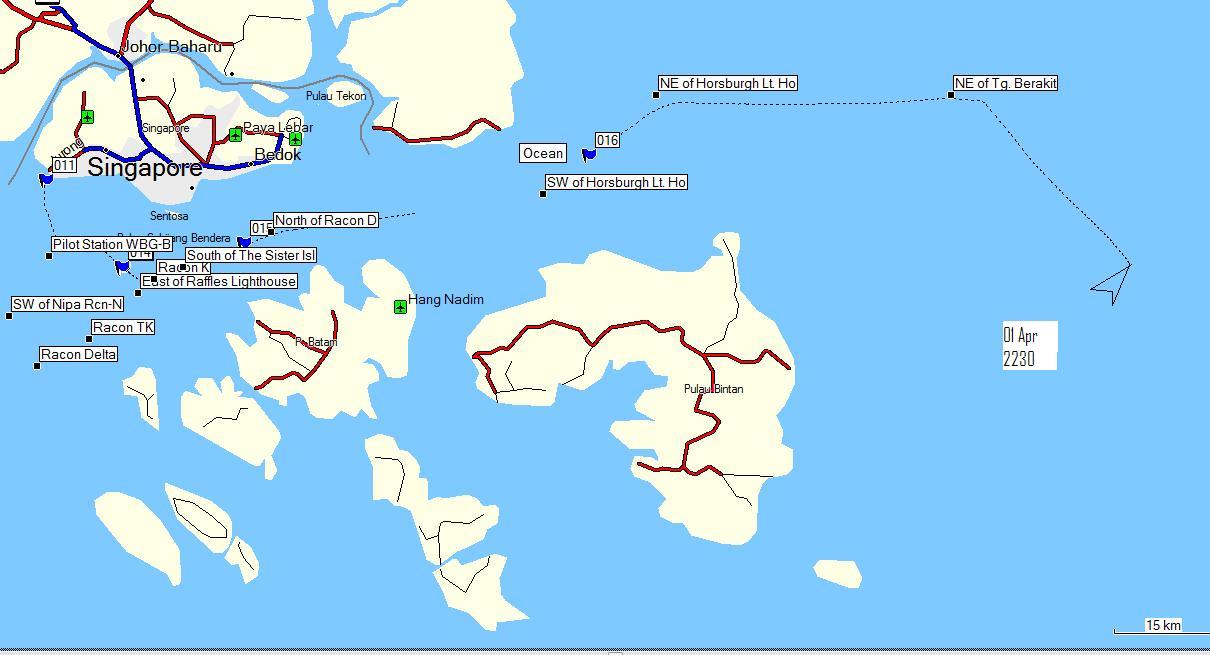
March 31, 2007: The ship is currently at anchor. Greg takes the crew boat out of Keppel shipyard in the morning (blue flag 11) along the black line to the ships anchorage (blue flag 12). Saturday morning, March 31st, Greg hopefully took his last trip from Keppel Shipyard to the Umuroa. We'll weigh anchor as soon as we get the windlass aboard which should be tomorrow April 1st.
Umuroa at anchor in the Singapore Harbor
The ship left the Quay (blue flag 11 on the Singapore Harbor Map) on Monday March 24th.
March 31, 2007: The ship is currently at anchor. Greg takes the crew boat out of Keppel shipyard in the morning (blue flag 11) along the black line to the ships anchorage (blue flag 12). Saturday morning, March 31st, Greg hopefully took his last trip from Keppel Shipyard to the Umuroa. We'll weigh anchor as soon as we get the windlass aboard which should be tomorrow April 1st.
Umuroa at anchor in the Singapore Harbor
April 1, 2007 (no fooling): The windlass was brought on board at 3:45 am and repairs were complete just before dawn. The anchor was dropped and 7 chains were hoisted back on deck. Greg took pictures of dawn in Singapore as he waited for the shipyard workers to leave and the last bits of equipment and refuse and the gangway to be removed. Pilots are scheduled for 10:00 am.
Windlass Repairs and Singapore at Dawn
April 1, 2007 (2030): The current position and previous course of Umuroa is shown on the Singapore Harbor Map.
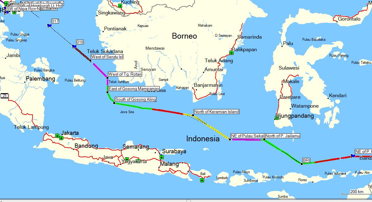
April 2, 2007 (0630): The current position and some of the previous course of Umuroa is shown on the Around Borneo Map. It's the blue flag (017).
April 2, 2007 (1700): The current position and some of the previous course of Umuroa is shown on the Around Borneo Map. It's the blue flag (018). Greg crossed the Equator for the first time on this stretch.
April 2, 2007 (2100): The current position and some of the previous course of Umuroa is shown on the Around Borneo Map. It's the black square (West of Serutu Island). The moon is full and very bright and it was easy to spot Serutu and her sister islands.
April 3, 2007 (0700): The current position and some of the previous course of Umuroa is shown on the Around Borneo Map. It's the end of the yellow line between the black square waypoints West of Tg Rotan and East of Gosong Mampango. The water is almost glassy calm and a nice sunrise.
April 3, 2007 (2020): The current position and some of the previous course of Umuroa is shown on the Around Borneo Map. The current position is the end of the green line. The water has been glassy calm all day and the sunset was picture perfect. The Java Sea is relatively shallow, 30 - 50 meters deep with a fair amount of shoals. Lots of very small fishing boats and a fair amount of tankers. Moon is very bright again tonight.
April 4, 2007 (0700): The current position and some of the previous course of Umuroa is shown on the Around Borneo Map. The current position is the end of the red line. Pretty calm still with more clouds.
April 4, 2007 (1120): The current position and some of the previous course of Umuroa is shown on the Around Borneo Map. The current position is the end of the gray line and we've just turned around the last way point which was Keramian Island. There were quite a few small fishing boats in this stretch of water. Pretty calm water although we are going to hit some squalls in the next hour or so. It will cool things off a bit.
April 4, 2007 (2200): The current position and some of the previous course of Umuroa is shown on the Around Borneo Map. The current position is the end of the yellow line and we've just turned around the last way point which was NE of Pulau Sekai. It rained heavily once and showered a couple times. It cooled and cleaned off the ship. The seas are still very calm and it's a very pleasant evening.
April 5, 2007 (0720): The current position and some of the previous course of Umuroa is shown on the Around Borneo Map. The current position is the end of the magenta line.
April 5, 2007 (1100): We slowed down to a crawl for a couple hours (fuel pump issues) near the Palau-Palau Sabalana which loosely translates into the Sabalana Islands. This was also a waypoint and we turned more to the South. It gave Greg a chance to take some pictures. There are also pictures of the chart for the voyage from the cockpit. Notice the penciled lines with the time. The farther apart, the faster we are going. You should be able to see the Palau-Palau Sabalana Islands in the pictures and on the chart and the most current position on the chart.
Photos from Palau-Palau Sabalana
April 5, 2007 (2150): The rest of the day was extremely nice. Good weather with just a tiny bit of rain. We sailed by Palau TanaJampea, Tana Malalla and Kalao at Sunset and also had a barbque on the stern this evening so lots of pictures from that. Currently in the Flores Sea between Flores and Sulawesi, Indonesia.
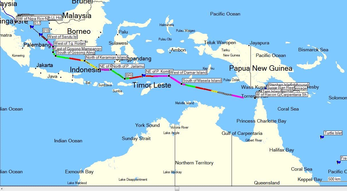
April 6, 2007 (0530): Beautiful predawn with a mostly clear sky and lots of stars. Current location is the end of the Green Line.
April 6, 2007 (2100): Another great day of calm seas and very sunny partly cloudy weather. Passed several dormant volcanos (pictures) and currently off the North Coast of East Timor. Current location is the end of the red line.
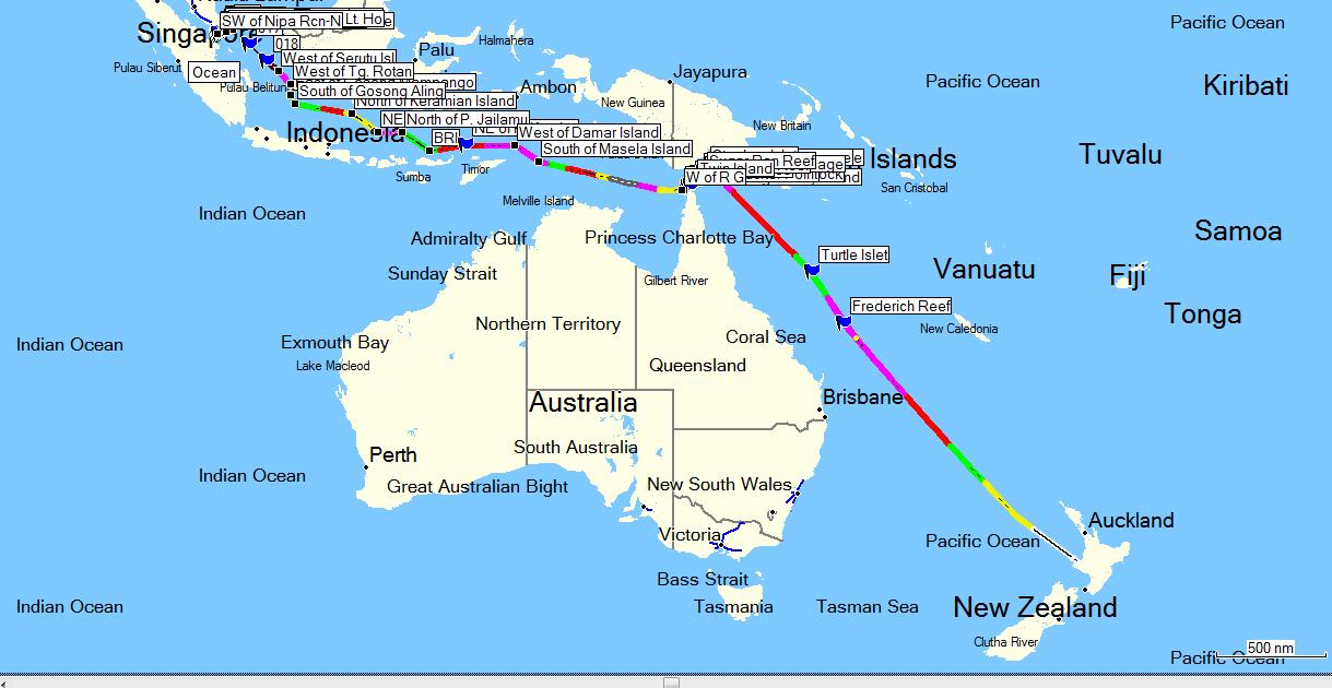
April 7, 2007 (0700): It rained around midnight which is a good time to rain. Partly cloudy but very nice this morning. Umuroa is continuing her steady pace to New Zealand. Current location is the end of the gray line just past the waypoint "West of Damar Island." We have one more waypoint before we take the long leg to the Torres Strait.
April 7, 2007 (2120): It rained on and off all day. The seas picked up to 1-2 meters. We have reached the last waypoint before the Torres Strait leaving the Banda Sea and we will be on this leg until the morning of the 10th. Umuroa is continuing her steady pace to New Zealand. Current location is the end of the magenta line just past the waypoint "South of Masela Island."
April 8, 2007 (0700): It is a nice morning. The seas are a bit choppy with some clouds but it looks like it will be a nice day. Current position is the end of the Green line in the Arafura Sea.
April 8, 2007 (2230): It turned out to be not such a nice day. The waves were choppy and we had a 15 20 knot wind at our head. Current position is the end of the Red line in the Arafura Sea. We took a lot of pictures in the engine room. Tomorrow, engine room pictures and the Haka from the naming ceremony.
April 9, 2007 (0600): It is a very cloudy and dreary morning. The wind seems a bit less. Current position is the end of the yellow line. Today we took pictures of the cafeteria and lunch today was BLAT's (Bacon, Lettuce, Avocado and Tomato). These reminded me a bit of Muffalettas, regardless they were excellent. We have several great chefs on board, notably a great pastry chef.
April 9, 2007 (2130): It is a very rainy and windy tonight and was most of the day. The wind seems a bit less. Current position is the end of the grey line. Someone turned the laundry into a tattoo parlor. Photos of that tomorrow.
April 10, 2007 (0710): It is still windy and 2-3 meter seas but no rain and a bit brighter this morning. Current position is the end of the magenta line. We should make the pilot station for the Torres Strait by 6:00 pm today. We did but we waited till the morning to go through. Pete Hunter took us on a tour of the motor control centers and other electrical gear.
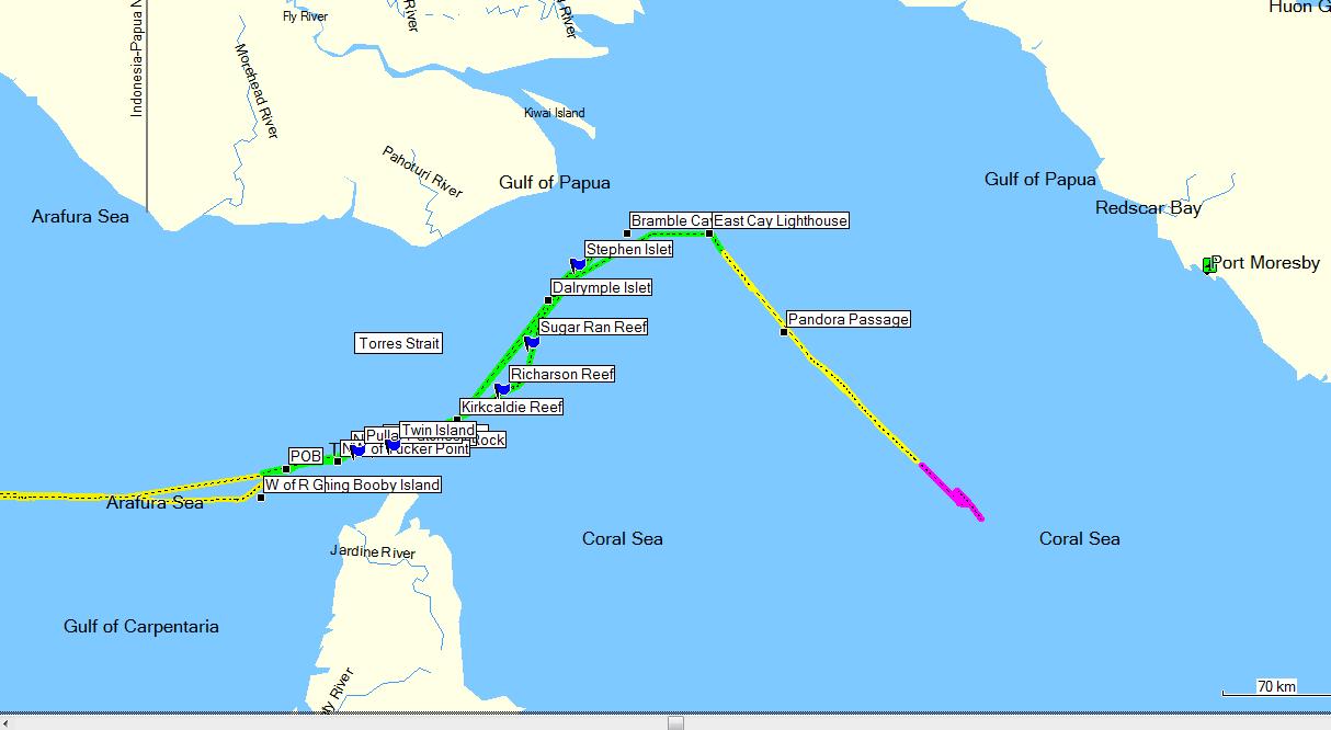
April 11, 2007: The pilot flew in in the morning. Interesting day sailing through the Torres Strait. First set of pictures through Booby Island.
April 11, 2007: The pilot left that evening at 7:30 pm. More photos including a French Frigate
April 12, 2007: Engine trouble left us rolling in the Coral Sea for half the day.
April 13, 2007: Moved between 8 and 9 knots. Rough sea and very strong head winds. Saw several flying fish.
April 14, 2007: The Indonesian crew girl told me, "The Pacific is never calm." Noticed the birds that were feeding on the flying fish at the bow. There were about 6 - 8 hanging up on the turret superstructure. The winds gusting at 30 knots. The birds were very delicate with their flying in such wind. Very amazing flight.
April 15, 2007: The promised better conditions don't materialize yet. Lots of wind and pretty nasty seas.
April 16, 2007: Perfect weather. The Coral Sea couldn't be much more beautiful. But it's a Monday, fell over backwards with a very heavy valve and smashed the shit out of my shin and forearm. New theory for Greg on pi and other wanderings in the vast expanse of his head. Barbque on the fantail. Perfect, bacon wrapped fillets, ribeyes and satay.
April 17, 2007: Another beautiful day. Continuing a klutzy week, stuck my finger in my eye in the shower.
April 18, 2007: Too tired all day from no sleep the night before
April 19, 2007: More clouds and a little roll to the ship. Have a headache still (sticking my finger in my eye? or the roll?). Propeller is vibrating from something in the middle of the night.
April 21, 2007: Looks like we'll get to New Plymouth just after 10:00 pm tonight. No prospect of a late chopper tonight. So we'll be getting off the ship tomorrow. A very nice double rainbow greeted us to New Zealand
April 22, 2007: Early morning wake up, chopper came out with an immigration crew, processed in the A deck meeting room and flew off the ship. Walked down the road to the airport terminal and caught the next flight to Auckland.
Photos from the Arrival and Other Trips
